Service hotline
+86 0755-83975897
 en
en Release date:2021-12-29Author source:KinghelmViews:2414
At 9:43 on June 23, China successfully launched the 55th navigation satellite of Beidou system and the last global networking satellite of Beidou 3 with a long march 3B carrier rocket at Xichang Satellite Launch Center. So far, the constellation deployment of Beidou 3 global satellite navigation system has been fully completed half a year ahead of the original plan.
Since the 1980s, China began to explore the development path of satellite navigation system suitable for national conditions, and formed the "three-step" development strategy. Since the Beidou-1 system project was approved in 1994, China has launched 59 Beidou satellites (including 55 Beidou navigation satellites and 4 Beidou navigation test satellites) in 26 years.
How important is satellite navigation system to a country? What does Beidou's global networking mean? Uncle Ku is talking to you today.
one
"First show" of satellite navigation system
At present, satellite navigation system provides convenience for all aspects of our life, but it was originally tailored for national defense and security.
The "first show" of satellite navigation system was in the Gulf War.

After the desert storm operation of the Gulf War in 1991, there were many abandoned vehicles along the road where Iraqi troops retreated.
In 1991, under the leadership of the global positioning system (GPS), the multinational force dominated by the [敏感词] [敏感词] quickly passed through the desert area regarded as a forbidden area by the Iraqi army, surrounded it and caught the opponent unprepared.
The war, which was initially predicted to become a stalemate, ended with 42 days of air strikes and 100 hours of ground operations, and the Iraqi army was completely defeated.
With the blessing of "God's perspective", the command and control of sea, land and air forces in the army, force mobilization, material support, battlefield rescue and precision attack with precision guided weapons have become possible.

On March 2, 1991, in Operation Desert Storm in Kuwait, the oil well was ignited before the withdrawal of Iraqi troops.
For example, the [敏感词] Department of defense purchased 8000 small GPS receivers worth more than $40 million. Under its information support, the [敏感词] mechanized infantry unit can locate its position with an accuracy of less than 30 meters, and can generate a scheme for the next node according to the March plan.
Since then, the satellite navigation system has continued to function in the war:
*On June 2, 1995, a [敏感词] F-16 fighter plane was shot down by Serbian armed missiles over Bosnia and Herzegovina. After parachuting and escaping, pilot o'gradi landed in the Serb controlled area. After suffering from ants, weeds and rain for 6 days and avoiding repeated searches by Serb forces, he was finally rescued by GPS.
*In the Kosovo war, after the [敏感词] F-117 stealth bomber was shot down, the pilot was found and rescued within 7 hours relying on the rescue device of the pilot's GPS receiver.
*In August 2004, the [敏感词] [敏感词] conducted an unusual air drop experiment, programmed the coordinates of the landing area for accurate positioning, and then controlled the flight through the motor traction line. Finally, it landed accurately, raising the launch height to 3200 meters.
Note: the delivery accuracy of traditional airdrop depends on external environmental factors such as aircraft altitude and wind speed at that time. Generally, the low altitude delivery of ordinary parachutes is less than 610m. Although the landing point is accurate, the aircraft will be completely exposed to the enemy.
Whether it is "one move to defeat the enemy" or rescue behind the enemy, the satellite navigation system has greatly increased the probability of mission success. Moreover, the satellite navigation system has also completely changed the form of war and contributed a new term - "surgical strike".
The technological innovation of Tomahawk cruise missile is a typical case.

In 1991, the [敏感词] [敏感词] "Wisconsin"warshipLaunch to Iraqi targets“OMAHAWK”Missile.
In the Gulf War, only 142 of the 282 missiles launched by the [敏感词] Navy into Iraq hit 42 of the 50 scheduled targets. Two years later, the United States launched 45 Tomahawk missiles to attack seven buildings in Iraq's southern industrial zone, with a success rate of only 64%.
In the same year, the [敏感词] [敏感词] launched 23 more Tomahawk missiles against the intelligence agencies in Baghdad, and only 18 hit the target.
The low hit rate comes from the composite guidance mode of "inertial navigation + contour terrain matching (TERCOM) + digital scene matching correlator (DSMAC)".
On the one hand, using a separate inertial navigation, the cumulative error of the missile can reach more than ten kilometers in more than one thousand kilometers. Even if the "terrain matching guidance" is used for auxiliary correction, if the terrain in the flight path is too flat or there are too many mountains, coupled with factors such as night, smoke and bad weather, it will still affect the strike accuracy.
On the other hand, since the 1950s, the navigation performance has been improved by improving gyroscopes and accelerometers. This method of improving high-precision inertial navigation by relying solely on the performance of components has become more and more difficult.
After the Gulf War, the [敏感词] [敏感词] began to combine GPS with inertial navigation system.
To accurately attack fixed targets on the ground, the target must be accurately located by GPS. During photographic reconnaissance, GPS is used to accurately determine the orbit position and altitude at the photographing time. These data are used as guidance target data, or directly bound in the guidance computer, or transmitted to the guidance computer through data link to control the missile to fly to the area where the predetermined target is located, and then the target is finally determined through imaging unguided to carry out attack.
With GPS, the choice of missile flight route no longer depends on the map, and is no longer restricted by the characteristics of water area and terrain.
Even, due to the improved accuracy, during the Gulf War, the weight of the Tomahawk missile warhead was reduced from 450 kg to 320 kg, which can carry more fuel and increase the range by more than 50%.
In the Iraq war, the [敏感词] [敏感词] claimed that due to the use of GPS guidance technology, its air strike capability was six times higher than that in the Gulf War. In the past, it took several sorties to destroy a target, but now it can destroy several targets at a time.
two
Big country "burn money" competition
Of course, sharp tools are usually quite "burning money", and [敏感词]ns pay a very high price for it.
In 1973, the United States began to study GPS. Because it was built first. The application range is the widest, and GPS once occupied the dominant position.
In 1993, the United States had 24 satellites in orbit running full of satellites, distributed on six orbital planes, ensuring that 4 to 12 satellites can be seen at the same time anywhere on the earth, and three-dimensional positioning, velocity and time measurement can be realized anywhere and at any time on the earth. For decades, the United States has invested about $30 billion in GPS.
Satellite navigation system is too important. Even if it costs a lot, countries are still scrambling to invest in R & D.
The Soviet Union began to establish the GLONASS satellite navigation system in 1976. In 1995, a satellite constellation composed of 24 satellites was built, realizing the global coverage of satellite signals for the first time.
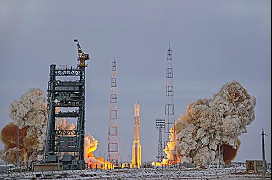
On December 25, 2008, a Proton-M rocket was launched with a GLONASS satellite at the Baikonur launch site in Russia.
The long-standing problem that has plagued Russia's aerospace industry is the lack of funds. Satellites beyond the scheduled service life could not be replaced in time and were unable to launch new satellites. By 2001, there were only seven satellites in orbit of the GLONASS system, almost on the verge of paralysis.
In 2002, the EU approved the construction of Galileo satellite navigation system. In just eight years, Galileo satellite navigation system fell into a "financial bottomless pit" because the actual investment cost far exceeded expectations.
If we want to continue the construction, the construction of satellite navigation system needs to be increased by 1.5 billion to 1.7 billion euros (about 13.96 billion to 15.83 billion yuan). The European Commission said that the increase in costs was mainly due to the increase in rocket launch fees, safety insurance premiums and costs caused by delays, and the Galileo plan may face long-term losses.
On December 17, 2015, the 11th and 12th satellites of the European Galileo satellite navigation system were launched from the kuru Space Center in French Guiana by a Russian "union" carrier rocket.
If you lose money, you have to build it! Satellite navigation systems are not only related to national security:
*In the State Grid, without the timing of satellite navigation system, it is impossible to ensure the accuracy and consistency of time; If there is no satellite navigation system to accurately locate the fault and quickly guide it to the fault point for emergency repair, the safe and stable operation of the power grid is an unknown.
*Commodity trading has a very urgent need to obtain fundamental information. In the past, there were problems of low timeliness and insufficient information when obtaining data and information through traditional channels, which led to the low market transparency of the global commodity supply chain. The "alternative data" provided by satellite navigation system provides new possibilities for improving the transparency of commodity market.
*Without the satellite navigation system, academic research on the earth's magnetic field and the movement of the earth's plates have all come to a standstill.
*Without the support of satellite navigation system, the positioning speed of super projects such as Hong Kong Zhuhai Macao Bridge will be greatly reduced, and the "China speed" cannot be displayed.
*Without navigation, it goes without saying how difficult it will be for the majority of "road blind" to travel.
In the 1980s, China began to explore the development path of satellite navigation system suitable for national conditions. At that time, GPS in the United States was a satellite navigation system with the most perfect constellation composition, the most stable positioning accuracy, the most widely used and market monopoly. Moreover, it was free and open to the world, and even foreign troops could use it.
Therefore, some people say that China "needs to spend so much energy to independently develop a positioning system?"
three
Beidou, it's not easy to say I love you
Of course!
First of all, GPS is a [敏感词] based satellite navigation system. The ownership, control and operation rights belong to the [敏感词] Department of defense.Civilian users in many countries are worried that the [敏感词] [敏感词] can stop civilian signals at any time. "Free lunch" is a huge risk.
Secondly, the accuracy is not enough.GPS contains two kinds of signals, [敏感词] code and civil code. Their precision levels are different. The former is millimeter level and the latter is decimeter level. Before 2000, the [敏感词] [敏感词] interfered with the civil signals released by GPS in order to reduce the accuracy of civil signals and protect [敏感词] information security.
In this context, in line with the development plan of regional and global development, China has successively built Beidou-1, beidou-2 and beidou-3 systems, and embarked on a road of satellite navigation system construction with Chinese characteristics.
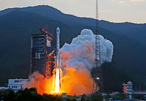
On September 30, 2015, Xichang Satellite Launch Center, China successfully launched the fourth new generation Beidou navigation satellite.
The road is not plain sailing. In terms of specific technology, problems emerge one after another.
For example, the prerequisite for the launch of navigation satellites is to have legal orbital position and frequency resources, which is a valuable resource for all countries in the world.The GPS of the United States and the GLONASS satellite navigation system of Russia have already accounted for 80% of the "golden navigation band".
It was not until 2000 that China won the temporary orbital position and frequency resources in ITU. However, there is a provision in the full interpretation and allocation of satellite frequency and orbit in the radio rules that applicants must use the frequency within 7 years.
Time is pressing!
On April 14, 2007, the Beidou satellite with an important mission finally took off, and the signal was sent back on April 17.
At this time, less than four hours remained before the deadline for the expiration of frequency applications stipulated by ITU.
The atomic clock problem was also a big obstacle.
The atomic clock on the navigation satellite uses the electromagnetic wave emitted when the atom absorbs or releases energy to time. Stable electromagnetic wave and precise instrument provide accurate time measurement for satellite navigation. How accurate can it be? For example, even from the extinction of dinosaurs to the present, the error is no more than 3 seconds. The atomic clock is therefore called the "heart" of the navigation satellite.
China tried to import rubidium atomic clock from abroad, but began to develop it independently after being rejected.
In 1997, scientists had no concept of the lifetime, reliability and satellite environmental adaptability of rubidium atomic clock. They had to experiment and improve repeatedly to find the best answer. For example, the microwave cavity, the core component of the rubidium atomic clock, directly determines the signal strength of the atomic clock. The team kept trying and developed the slotted tube microwave cavity in more than a year.
In addition, the team also invented a new rubidium spectrum lamp, which overcomes the main obstacles limiting the service life of rubidium clock and the adaptability of satellite environment.
Beidou-3 satellite began to use hydrogen atomic clock. The day stability of rubidium atomic clock is E-14 and that of hydrogen atomic clock is E-15.
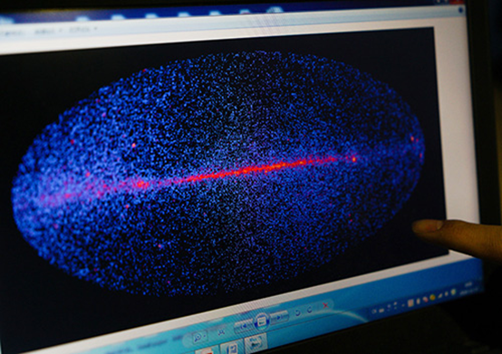
Space active hydrogen atomic clock independently developed by China.
At the end of 2000, China built the Beidou-1 system, which solved the fundamental problem of "where are we" for the first time. Since the project was approved in 1994, three geo satellites have formed the third satellite navigation system in the world, covering China's territory and surrounding areas. It has been used in China for six years.
At the end of 2012, the beidou-2 system was completed, with 14 satellites covering the Asia Pacific region. The positioning accuracy of the navigation system standard service in the Asia Pacific region is about 10 meters. Beidou-2 has established the technical system of Beidou and realized the dual-mode integration of continuous navigation and positioning report and the full constellation broadcasting of three frequency signals.
In 2020, beidou-3 will realize global networking, with 35 satellites covering the world. It can provide global users with positioning and navigation enhancement services with meter level, sub meter level, decimeter level and even centimeter level accuracy.
From the word "lack" - the shortage of key technologies and equipment, the shortage of talents for satellite navigation research, and the shortage of funds, to the completion of Beidou global networking, all the hardships and glory are unspoken.
four
Are we really "better than the blue"?
In 2007, the United Nations identified the United States GPS, China Beidou, Russia GLONASS and EU Galileo as the four major global navigation systems.
At present, Beidou's technologies are also constantly being updated.

On April 18, 2018, villagers of tawan village, Jinji Town, Litong District, Wuzhong City, Ningxia planted vegetables in the field using Beidou navigation.
For example, on the basis of Beidou 2, the positioning accuracy of Beidou 3 has been increased by 1 to 2 times, reaching the level of 2.5-5 meters. It is planned to provide civil users with positioning services with an accuracy of about 10 meters and speed measurement services of 0.2 meters / second free of charge.
In addition, beidou-3 navigation system can also provide users with precise surveying and mapping data with its advantages of high-precision positioning. Xie Jun, deputy chief designer of beidou-3 project and chief chief designer of beidou-3 navigation satellite, said, "measuring the subsidence changes of buildings after the earthquake, a few millimeters of subsidence can not escape Beidou's eyes."
Beidou, a late mover, has many advantages that other navigation systems can't match.
First of all, Beidou's unique short message function is a technological breakthrough that GPS does not have.In short, it is a two-way digital message communication function between user machine and user machine, and between user machine and ground control center. It can not only send signals, but also receive signals.
The short message sender first encrypts the communication application signal containing the receiver ID number and communication content, and then forwards it to the station through satellite; After receiving the communication application signal, the ground central station will be added to the outbound broadcast message of continuous broadcasting after de encryption and re encryption, and broadcast to the user via satellite; Then, the receiver user machine receives the outbound signal, demodulates and decrypts the outbound message, and completes a communication.
Short message, similar to the form of our daily short message, plays an irreplaceable role in various rescue.
During the Wenchuan earthquake relief, Beidou generation equipment sent the first message from the earthquake area. At that time, all communication means highly dependent on optical fiber and base stations were unusable due to extensive damage to infrastructure. The short message function of Beidou satellite navigation system quickly "goes online", which ensures that we make full use of the "72 hour golden rescue time" to the greatest extent.
In September 2018, after a navigable aircraft lost contact in Hotan mountain area, Xinjiang, it sent positioning information through Beidou short message, so that all the crew were rescued safely.
In case of forest fire, the Beidou handheld terminal can enable the front-line fire police to timely grasp the fire and do personal protection through the Beidou system's high-precision positioning technology and short message communication function, so as to facilitate the organization of evacuation of local people and strengthen the deployment of rescue forces in key protection areas.
In 2017, the application of Beidou was continuously promoted in fisheries. Fishermen said that now they worship two things when they go to sea: Mazu and Beidou. At present, more than 50000 fishing boats in the Bohai Sea, the Yellow Sea, the East China Sea and the South China Sea have been equipped with Beidou terminals. According to the statistics of Zhejiang Province in 2011, Zhejiang fishermen sent 13 million text messages using Beidou satellite.
In addition, GPS uses dual frequency signal, while Beidou uses triple frequency signal, it can better eliminate the influence of high-order ionospheric delay, improve positioning reliability, enhance data preprocessing ability, and greatly improve the fixing efficiency of ambiguity. If there is a problem with one frequency signal, the traditional method can be used to locate the other two frequencies, which improves the reliability and anti-interference ability of positioning.
Beidou is the first satellite navigation system in the world to provide three frequency signal service.
five
Civilian is the development direction
Now, Beidou has spread all aspects of our life: most of the world's mainstream mobile phone chips support Beidou system, which is becoming the standard configuration of smart phones sold in China; Shared single vehicle equipped with Beidou system to realize fine management; Watches, bracelets and student cards supporting Beidou system make people's daily life more convenient.
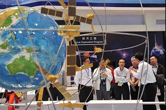
Beidou navigation satellite system model exhibited by China Aerospace Science and Technology Corporation.
It should be noted that these satellite navigation systems do not have to compete for life and death. Multi system compatibility and interoperability has become a development trend.
The U-2 reconnaissance aircraft has used China's Beidou satellite navigation system as a backup system for the aircraft in case of GPS failure. The watch worn by U-2 pilots also has built-in multiple navigation systems. In addition to GPS, it can also connect Beidou, GLONASS and Galileo systems.
Why get mixed up with competitors?
First, provide guarantee for normal operation.
According to the working principle of GPS, the receiver needs to "see" at least 4 navigation satellites at the same time to realize positioning. If a single navigation system is used, once the number of satellites over a certain area is limited, the receiver will be disconnected from a satellite, affecting the continuity of positioning service. After Beidou and GPS realize interoperability, users can receive satellite signals of two systems at the same time with one receiver. If the number of GPS satellites is not enough, there are Beidou satellites, and the positioning stability and accuracy will be higher.
Second, the satellite navigation industry generally follows the development law from [敏感词] to industry, then to civil, and from minority to mass.Beidou navigation system has been widely used in transportation, public safety, agriculture, forestry and fishery, hydrological monitoring, weather forecast, communication time series, power dispatching, disaster relief and disaster reduction, and compatibility can improve product performance, enhance user experience and add points to commercial competition.
At present, the international mainstream global navigation satellite system (GNSS) manufacturers adopt the multi system sharing mode, and the products generally support two or more satellite navigation systems. Beidou 3 has considered the compatibility with other satellite navigation systems at the beginning of design and construction, so that users can receive multiple signals on the terminal.
The era of Beidou's mass and large-scale application has come. As a strategic emerging industry, the satellite navigation and positioning market has evolved into a global industrial chain and strategic partnership worth nearly [敏感词] $100 billion a year. In 2017, the output value of China's satellite navigation and location services industry reached 255 billion yuan, a year-on-year increase of 20.4%. This figure is expected to reach 340 billion yuan to 350 billion yuan in 2020.
At present, China's cooperation with other countries is also advancing. Domestic Beidou basic products have been exported to more than 120 countries and regions. Beidou based land ownership, precision agriculture, digital construction and smart port have been successfully applied in ASEAN, South Asia, Eastern Europe, West Asia, Africa and other places.
This article is reproduced from“Uncle Ku said the lookout think tank”, support the protection of intellectual property rights. Please indicate the original source and author for reprint. If there is infringement, please contact us to delete
Copyright © Shenzhen Kinghelm Electronics Co., Ltd. all rights reservedYue ICP Bei No. 17113853
