Cars will face unprecedented changes in the field of autonomous driving. This change not only has a huge connection with the functional updates required in the driving process, but also includes major changes in the architectural design of the entire driving system development process. Among them, the high-precision map, as an important aspect of its positioning and navigation, will also undergo major design changes. This is mainly reflected in the following important aspects:
1) The deployment of roadside maps requires more strong support from government infrastructure departments, including a V2I-like Internet of Vehicles system, providing V2X scene rendering SDK, supporting custom rendering styles, and realizing personalized in-vehicle V2X applications. Using the roadside information path (PC5), the problem of the impact of blind spots on the map service due to cellular network coverage can be solved.
2) The real-time distribution of maps has also been upgraded from the original second level to the millisecond level. The high-precision map update and distribution capabilities tend to be deployed at the edge, realizing real-time map update and millisecond-level data distribution services, aiming to improve the real-time performance of its data transmission. .
3) The real-time high-precision map platform in the autonomous driving system is also gradually transitioning from the original distributed system to the centralized system. The high-precision map engine can provide real-time high-precision map application services for the automatic driving system, and help the application of automatic driving vehicles.
4) Maps need to establish more self-learning mechanisms, including the establishment of self-learning maps in shadow mode, and constantly update the map's cognition and learning of the environment.
5) Redefine the automatic driving function by the optimized map. This process is actually a process of iterating the automatic driving function based on the map.
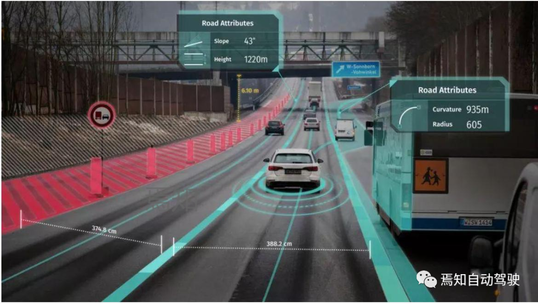 6) Provide diversified basic map services
In the future, HD Map will have corresponding management services and technical advantages through continuous optimization and updating, including perfect function iteration, system data security, multi-type data support, multi-terminal authorization support, high-quality service and operation and maintenance system, and data online Several aspects of the upgrade service.
Among them, the indicators of complete functions include: data distribution, collection, subscription, notification functions, dynamic data online compilation, visual online display editing, Campaign, Map Learning crowdsourcing update, data simulation platform, etc.
Multi-data support includes: version static layer, effective dynamic data support, streaming data support, OSO custom data support, incremental data release update, Map data integrity assurance.
System data security includes: complete network security configuration, firewall, VPC, multi-level system authority management, users, roles, permissions, resources, https two-way encryption, data signature, and HSM device integration.
Multi-terminal permission support includes: based on OAuth2 authorization management, massive concurrent response, Auto Scaling dynamic scaling, complete API SDK development kit support, 2V terminal development kit and function integration, OTA update, VCDN, to ensure data security and speed.
7) V2X high-precision map service supporting edge computing
In the future, the development of autonomous driving will mainly move towards two major directions: intelligence and network connection. For the deployment of high-precision maps, the most important points are a series of upgrades and changes on the cloud, road and vehicle. Among them, the cloud transformation mainly involves high-precision map services, fragmented data aggregation, data edge connection, and data fragmentation. The roadside terminal mainly involves several aspects such as sharded map crowdsourcing update, map version management, map subcontracting, roadside dynamic information optimization, and map message service. When applied to the vehicle end, it is required to update the subcontracted data fusion, V2X scene restoration, and high-precision map engine.
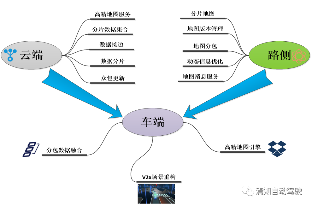 The above iterative update process of the map can be applied to realize the L4/L5 level unmanned driving function, generate the relevant robot control mode, and can also be used in the realization of commercial vehicles, and finally realize unmanned and even remote driving.
Mass production-oriented high-precision fusion positioning solution
Obviously, in order to achieve precise positioning and continuous expansion to improve the functional performance of the high-precision map, it must be obtained by continuously optimizing its own fusion positioning scheme. This process consists of two main software algorithms. One is to use the full state-extended Kalman filter for dynamic optimal estimation of vehicle pose; the other is to use visual sensors to obtain semantic information of the road environment, and to obtain precise locations through accurate map matching algorithms. In addition, there is a need to improve economy, fit and overall performance. By choosing and configuring the industrial-grade vehicle terminal RTK: using high-performance industrial-grade 32-bit processor, built-in high-precision RTK board; establishing a channel with Qianxun platform through 3G/4G/5G, sending GGA information to the differential server, and receiving differential After the information is received, the precise location information is output through RS232.
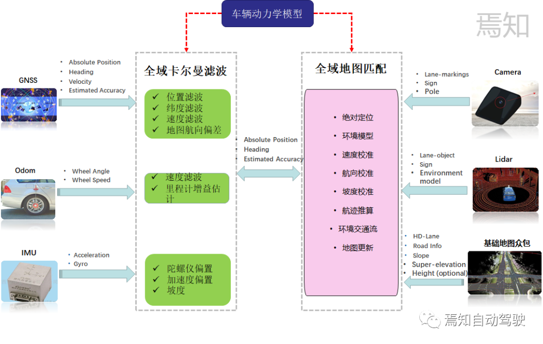 By choosing consumer-grade sensors, that is, sensors that have been installed on the car (such as cameras suitable for intelligent driving systems, lidar radar, etc.) for positioning fusion (such as visual SLAM, laser SLAM) Improve positioning performance. For the high adaptability solution, a unique hardware adaptation layer (such as an independent domain controller system) and a software adaptation layer (such as a standard C language interface) are mainly used to avoid platform dependence. High-performance requirements mainly involve the output of requirements for both horizontal and vertical positioning. Generally, the lateral positioning error is required to be 20cm, the longitudinal positioning error is required to be 1m, and the heading angle positioning error is 0.5°. At the same time, the signal loss rate for GNSS in the longitudinal positioning error should be less than 0.3%. In addition, an external IMU supporting 1000Hz and a camera input solution with a frequency of 50Hz are also required.
In addition to the overall architecture settings of the map, the data publishing mode also requires a minimum traffic cost to complete the high-precision map update and support streaming incremental publishing. This process includes streaming an appropriate amount of tiles, incrementally updating data, browsing rich datasets, and distinguishing catalogs, levels, and tiles to enable hierarchical query. Finally, the cloud historical data can be retrieved on demand, and any version information can be traced back at any time.
Map distribution and map vertical packaging
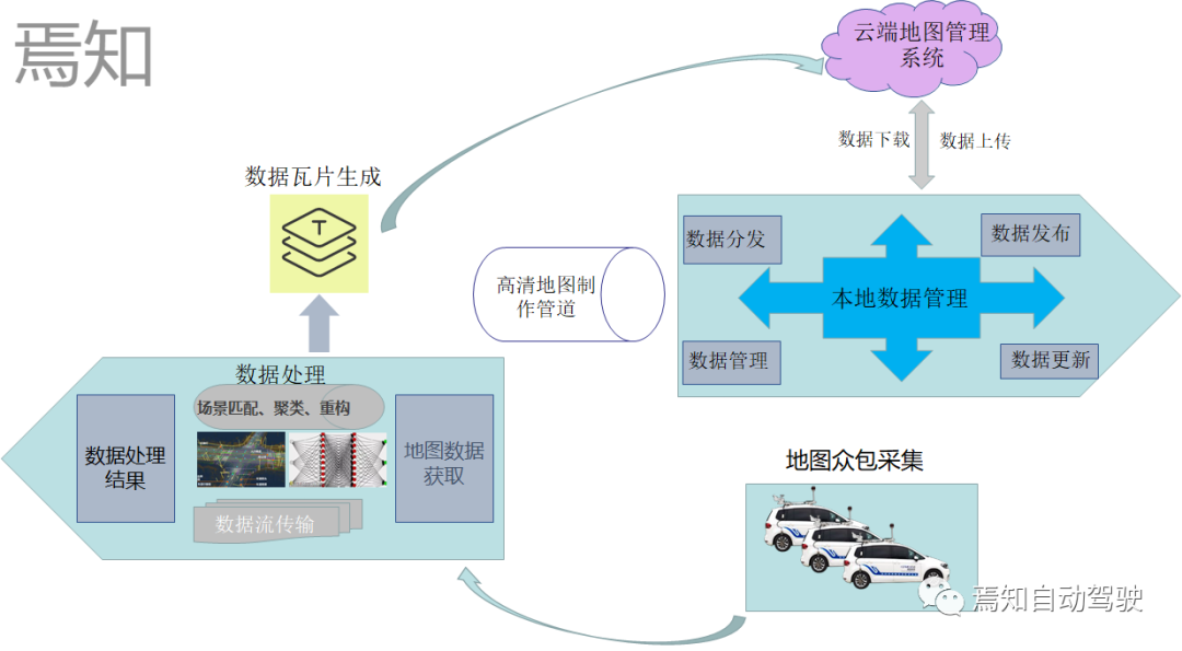
The most important process of high-precision map is the collection and distribution of map crowdsourcing. Regarding the collection of crowdsourced map data, it can actually be understood that the road data collected by the user through the self-driving vehicle's own sensors, or other low-cost sensor hardware, is transmitted to the cloud for data fusion, and the data is improved through data aggregation. Accuracy to complete the production of high-precision maps. The entire crowdsourcing process actually includes physical sensor reporting, map scene matching, scene clustering, change detection and updating.
Where will the new architecture of autonomous driving based on map development go?
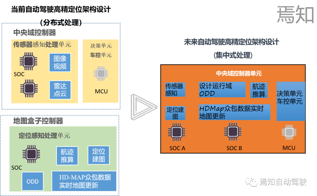
The high-precision map architecture of the current autonomous driving system is still oriented to the distributed way, and its key items include map crowdsourcing, the analysis of the original information of the high-precision map by the map box, and how the map integrates the input data of other sensors. Here we note that the future autonomous driving system architecture will continue to evolve from a distributed development method to a centralized one. The centralized approach can be seen as a three- or two-step process:
Step1: Fully centralized control scheme in intelligent driving domain
That is, the intelligent driving ADS and the intelligent parking AVP system are fully centralized controlled, and a set of central preprocessing devices are used to integrate, predict, and plan the information requested by the two systems. The processing methods of all sensing and data units related to intelligent driving and intelligent parking (high-precision maps, lidar, fully distributed cameras, millimeter-wave radar, etc.) will be integrated into the central domain control unit accordingly.
Step2: Fully centralized control solution for intelligent driving domain and intelligent cockpit domain
This approach is the second stage of realizing a fully centralized and distributed approach, that is, the development of all functions covered by the intelligent driving domain controller (such as automatic driving, automatic parking) and the development of all functions covered by the intelligent cockpit domain (including the driver Monitoring DMS, audio and video entertainment system iHU, instrument display system IP) for integrated coverage.
Step3: Fully centralized control scheme of intelligent vehicle domain
Here is a fully integrated control method that includes intelligent driving, intelligent cockpit and intelligent chassis domains. That is, the three main functions are integrated into the central control unit of the vehicle, and the later processing of the data will generate more performance (computing power, bandwidth, storage, etc.) requirements for the domain controller.
Here we focus on the development of high-precision map positioning will be more oriented to centralized design in the future. We will go into detail.
The figure above shows the development trend of the architecture for high-precision maps in the control of future autonomous driving systems. In the future, the autonomous driving system will focus on integrating the perception unit, decision-making unit, and map positioning unit into the central domain control unit, aiming to reduce the dependence on the high-precision map box from the bottom. The design of its domain controller fully considers the full integration of AI computing chip SOC, logic computing chip MCU, and high-precision map box.
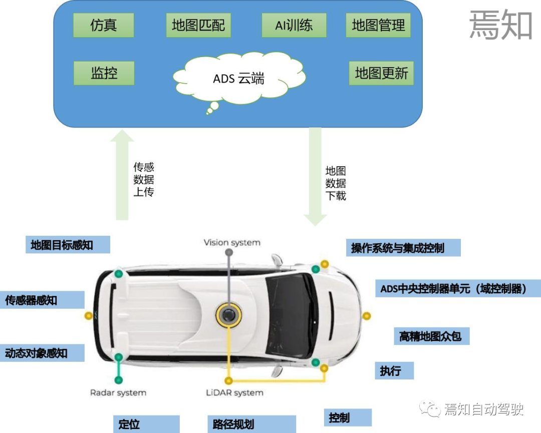
The above figure shows the corresponding high-precision map sensing data collection, data learning, AI training, high-precision map service, simulation and other services under the entire cloud control logic. Dynamic data perception, map target perception, positioning, path planning and other content constantly update map data and upload OTA to the cloud to update the overall crowdsourced data.
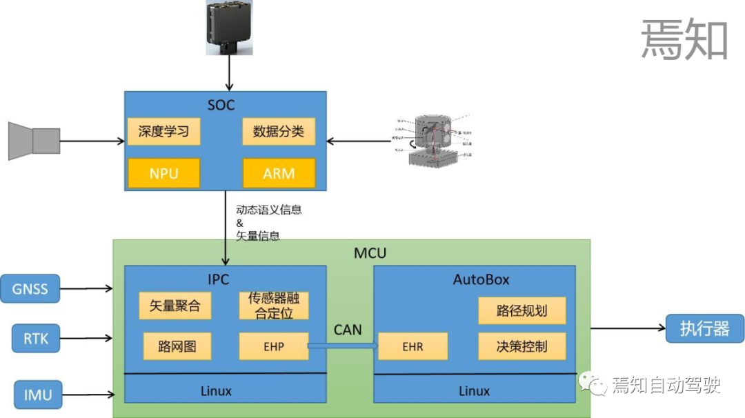
The process of how to generate high-precision map data that can be processed by the autonomous driving controller has been described above. We know that the raw data processed by the high-precision map is EHP data. The data actually contains the following main data support:
1: Received external GPS location information;
2: The location information is matched to the map;
3: Establish road network topology information;
4: Send data through CAN;
5: Integrate some navigation data;
The data is generally processed directly from the HDMap sensing end through Gigabit Ethernet and then input to the high-precision map central processing unit, which we call the "high-precision map box". Further processing of the data through the map box (this actual processing process will be explained in detail in subsequent articles) can be converted into EHR (actually CanFD) data that can be processed by the automatic driving controller.
For the next-generation autonomous driving system, we are committed to integrating the information of the high-precision map into the autonomous driving domain controller for overall processing. This process means that our autonomous driving domain controller needs to connect all the data to be performed by the map box. Analysis work, then we need to focus on the following points:
1) Can the autonomous driving domain controller AI chip process all the sensor data needed to include high-precision maps?
2) Does the logic operation unit of the high-precision positioning map have enough computing power to perform sensor data information fusion?
3) Does the entire underlying operating system meet the functional safety requirements?
4) What connection method is adopted between the AI chip and the logic chip to ensure the reliability of data transmission, Ethernet or CanFD?
In order to answer the above question, we need to analyze how the controller as shown in the figure below handles the high-precision map data.
As the AI chip of the autonomous driving system, SOC is mainly responsible for the basic processing of sensor data in the future high-precision map data processing, including camera data, lidar data, millimeter wave data, etc. In addition to the basic data point cloud fusion and clustering, the applied processing method also includes commonly used deep learning algorithms, and ARM core is generally used for central computing processing.
As the logic operation unit of the autonomous driving domain controller, the MCU will subsequently undertake all the logic calculations required by the original high-precision map box. Including front-end vector aggregation, sensor fusion positioning, establishing road network map, and the most important function of replacing the original map box, converting EHP information into EHR signals (for the central processing unit MCU how to effectively convert EHP information into EHR information will be described in detail in a later article), with efficient signaling via the Can wire. Finally, AutoBox, a logic operation unit, is used for path planning, decision control and other operations.
In the future, autonomous driving will tend to integrate all the data information processed by the high-precision map from the original map box into the autonomous driving domain controller, aiming to establish a real central processing fusion with the whole vehicle domain controller as the integration unit. . This method not only saves more computing resources, but also enables AI data processing algorithms to be better applied to high-precision positioning, ensuring the consistency of the two's environmental cognition. In the future, we need to pay more attention to the important direction of high-precision sensor data fusion, and make more efforts in chip computing power, interface design, bandwidth design and functional safety design.
The "Kinghelm" trademark was originally registered by the Golden Navigator Company. Golden Navigation is a direct-selling manufacturer of GPS antennas and Beidou antennas. It has a very high reputation and reputation in the Beidou GPS navigation and positioning industry. Its research and development products are widely used in bds satellite navigation and positioning wireless communications, etc. field. The main products include: RJ45-RJ45 network, network interface connector, RF connector adapter cable, coaxial cable connector, type-c connector, hdmi interface type-c interface, pin header, SMA, fpc, FFC Antenna connector, antenna signal transmission waterproof connector, hdmi interface, usb connector, terminal terminal line, terminal board terminal block, terminal block, radio frequency rfid label, positioning and navigation antenna, communication antenna antenna cable, glue stick antenna suction cup antenna, 433 antenna 4G antenna, GPS module antenna, etc. Widely used in aerospace, communications, military, instrumentation and security, medical and other industries.
The content comes from the network/surveying and mapping academic information. This website only provides reprints. The opinions, positions, technologies, etc. of this article have nothing to do with this website. If there is any infringement, please contact us to delete it!


